Astley and Bedford Mosses
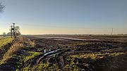
Astley and Bedford Mosses are areas of peat bog south of the Bridgewater Canal and north of the Liverpool and Manchester Railway. They are situated about 2+1⁄2 miles (4 km) south-east of Leigh, in Astley and Bedford, Greater Manchester, England. They are among the last remaining fragments of Chat Moss, the raised bog that once covered a large area, of around 10+2⁄3 square miles (28 km2), south Lancashire north of the River Mersey. Astley Moss was designated a Site of Special Scientific Interest in 1989. Astley and Bedford Mosses, along with Risley Moss and Holcroft Moss, are part of Manchester Mosses, a European Union designated Special Area of Conservation.
Read article


Top Questions
AI generatedMore questions
Nearby Places
Chat Moss
Peat bog in the City of Salford, Greater Manchester, England
Leigh Rural District
Local government area in England, abolished 1974

Astley railway station
Disused railway station in Astley, Wigan

Astley Green Colliery

Morleys Hall
Building in Astley, Greater Manchester, England
Lamb's Cottage railway station
Former railway station in England
Flow Moss railway station
Former railway station in England

Astley Mosley Common (ward)
Electoral ward in England